Old traffic circle gets new traffic flow to make Mississauga neighbourhood safer
Published August 11, 2023 at 3:26 pm

Drivers, cyclists and pedestrians will notice a few major changes to a main street and surrounding area in a west Mississauga neighbourhood starting this weekend geared toward making the roads safer for everyone.
Chief among them will be a change in traffic flow/direction at one of the city’s oldest traffic circles located near two elementary schools and a small plaza.
The latest installment in an ongoing City of Mississauga effort aimed at making city streets safer and more attractive to those who use them will be seen in The Credit Woodlands area, near Dundas St. W. and Erindale Station Rd., throughout the rest of August and beyond.
It’s part of the City’s Sharing Lanes initiative, which has been implemented in other areas of Mississauga the past few summers with positive results, officials say.
City officials say this year’s project will test new ideas on some of the sidewalks and roadway sections of The Credit Woodlands, specifically around Bert Fleming Park and two nearby elementary schools, Springfield Public and St. Gerard.
One of the ideas being introduced is the implementation of a new traffic flow along The Credit Woodlands and the traffic circle located on that street by St. Gerard and the plaza.


Diagram shows new traffic flow/direction at The Credit Woodlands traffic circle. (Image: City of Mississauga)
The objective, officials add, is to increase safety for “vulnerable road users and improve access to Bert Fleming Park.”
The move is expected to make it easier for people to cross the street to get to and from the small park.
As officials launch this year’s initiative, which they say takes a “tactical urbanism” approach to community building, they did so armed with public feedback gathered earlier this year.
“Tactical urbanism is an approach to city building that uses affordable, temporary measures to demonstrate different uses of the roadway and public space,” a City spokesperson said in an earlier news release.
Plans for the space around The Credit Woodlands include:
- traffic calming measures including piloting a new configuration for the roadway around Bert Fleming Park
- vibrant designs on the roadway in front of the two nearby schools
- transformed streets where a section of the roadway is replaced with a car-free community plaza space that will provide space for things like seating and community activities
Input from residents was gathered earlier this year, the feedback helping the City understand what pedestrians, cyclists, transit users and drivers experience when travelling in the area, officials said.
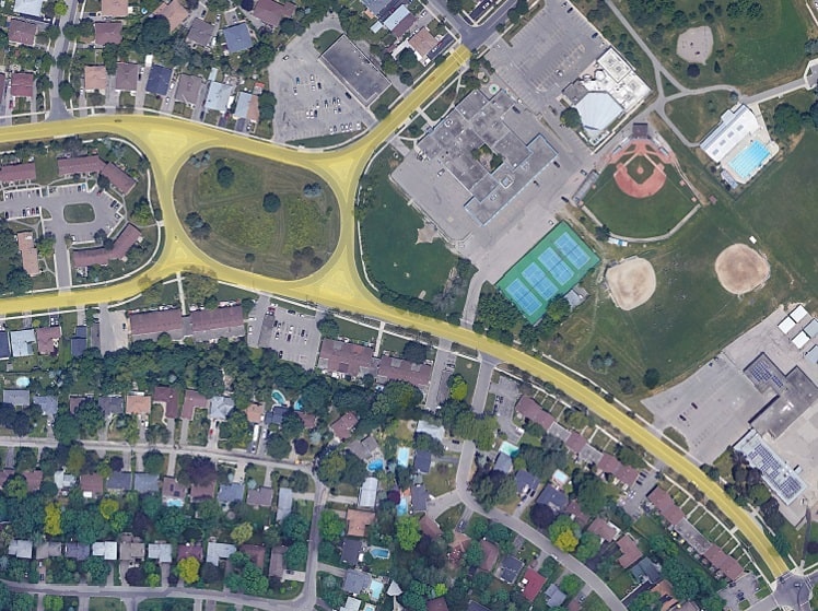
Aerial photo shows area of The Credit Woodlands, including the old traffic circle, that will take part in the Sharing Lanes initiative. (Photo: City of Mississauga)
Final plans were shared with the public in May, and now the effort is coming to fruition this weekend.
The City says tactical urbanism has been used by cities around the world to examine new ways to think about and enliven public spaces.
“The City of Mississauga identifies spaces that vulnerable road users may find uncomfortable or difficult to navigate, where the addition of tactical urbanism measures can have a positive effect,” Mississauga officials say.
The Credit Woodlands is the City’s fourth tactical urbanism project. Earlier projects include the Jaguar Valley Drive and Princess Royal Drive area in central Mississauga in 2022 and Living Arts Drive in 2019.
INsauga's Editorial Standards and PoliciesIf you’ve travelled along The Credit Woodlands recently around Bert Fleming Park, you’ll have seen our Sharing Lanes project coming to life!
This Sunday, August 13, road closures will be in place & vehicle traffic will be redirected around the park.
More:… pic.twitter.com/d1S3chIH68
— City of Mississauga (@citymississauga) August 11, 2023